High-precision positioning service - List of Manufacturers, Suppliers, Companies and Products | IPROS

High-precision positioning service Product List

1~8 item / All 8 items

Displayed results

Launch of New Plan for Corporate High-Precision Positioning Service "ichimill"

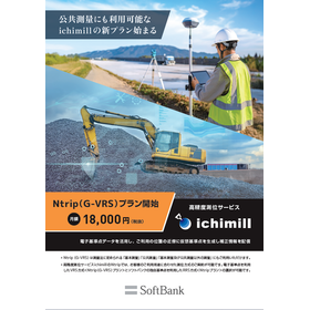
New "Ntrip (G-VRS) Plan" for ichimill: Now Compatible with Public Surveying

"ichimill" is a high-precision positioning service for corporate clients capable of achieving accuracy within just a few centimeters. Starting October 1, 2025, the new "Ntrip (G-VRS) Plan" is available. This plan utilizes the VRS method compliant with operational regulations for public surveying, allowing you to use it with confidence for public works projects. The "Ntrip (G-VRS) Plan" leverages data from the Geospatial Information Authority of Japan (GSI)'s Electronic Reference Points. It generates a virtual reference station near your location to distribute correction data. 【Features of the New "Ntrip (G-VRS) Plan"】 VRS Method: Generates a "Virtual Reference Station" near the user's location using GSI Electronic Reference Point data to transmit correction information. Seamless Transition: Utilizes approximately 1,300 GSI Electronic Reference Points. Users familiar with conventional VRS methods can transition and implement this system smoothly. First Domestic Software: Adopts Japan's first domestically developed VRS software. Cost-Effective: Available at a low cost (18,000 JPY/month excluding tax). For more details, please download the PDF or feel free to contact us.

  • Other construction services
  • High-precision positioning service

Added to bookmarks

Bookmarks list

Bookmark has been removed

Bookmarks list

You can't add any more bookmarks

By registering as a member, you can increase the number of bookmarks you can save and organize them with labels.

Free membership registration

High-precision positioning service "ichimill"

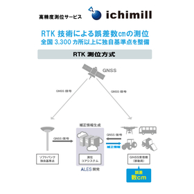
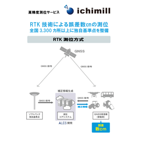
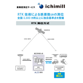
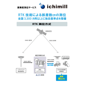
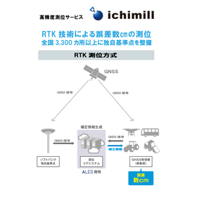
Positioning with an error of a few centimeters using RTK technology. Establishing unique reference points at over 3,300 locations nationwide.

Ichimill is a service that enables positioning with an accuracy of a few centimeters by performing RTK positioning using signals received from GNSS, such as the quasi-zenith satellite "Michibiki." *1 GNSS (Global Navigation Satellite System) refers to the collective term for satellite positioning systems such as QZSS (Quasi-Zenith Satellite System), GPS, GLONASS, and Galileo. *2 RTK (Real Time Kinematic) positioning is a method that allows for high-precision positioning by using two receivers, a fixed station and a mobile station, to exchange information in real-time between the two points.

  • Other measuring instruments
  • High-precision positioning service

Added to bookmarks

Bookmarks list

Bookmark has been removed

Bookmarks list

You can't add any more bookmarks

By registering as a member, you can increase the number of bookmarks you can save and organize them with labels.

Free membership registration

<Use Case> Achieving Autonomous Driving with High-Precision Location Information Acquisition

Support for remote operation and reduction of collision accidents.

Accurate positioning information is essential for controlling vehicles, so the realization of autonomous driving depends on how precisely positioning can be performed. In a demonstration experiment conducted at sea by e5 Lab in 2020, receivers of "ichimill" were installed at the four corners of the hull. Not only the position of the ship but also its orientation and tilt were obtained with centimeter-level accuracy. Funai from SoftBank, who participated in this demonstration experiment, stated, "Of course, we can track the ship's route, and it can also be used to prevent ship collision accidents. In particular, I believe that using 'ichimill' will enable highly accurate steering assistance during berthing, which is when the most attention is required in ship operation. In the future, we would like to apply this to remote control and autonomous operation of vessels."

  • Other measuring instruments
  • High-precision positioning service

Added to bookmarks

Bookmarks list

Bookmark has been removed

Bookmarks list

You can't add any more bookmarks

By registering as a member, you can increase the number of bookmarks you can save and organize them with labels.

Free membership registration

High-precision positioning service for measurement "ichimill"

Achieving positioning with an error of a few centimeters. Improving the accuracy of terrain mapping.

In the surveying industry, particularly in terrain mapping, the acquisition of detailed and accurate terrain data is essential. Even slight positioning errors can affect the recognition of terrain shapes and dimensions, potentially leading to rework during the design and development stages, as well as discrepancies with the actual site. High-precision positioning serves as the foundation for reliable terrain data. The high-precision positioning service "ichimill" addresses this challenge by providing positioning accuracy within a few centimeters, thereby supporting more reliable terrain mapping. 【Usage Scenarios】 - Extensive terrain surveying - Acquisition of detailed terrain data - Collaboration with drone surveying - Current condition surveying at construction sites 【Benefits of Implementation】 - Improved accuracy of terrain data - Increased efficiency of surveying operations - Enhanced reliability during design and development stages - Reduction of rework

  • Other measuring instruments
  • High-precision positioning service

Added to bookmarks

Bookmarks list

Bookmark has been removed

Bookmarks list

You can't add any more bookmarks

By registering as a member, you can increase the number of bookmarks you can save and organize them with labels.

Free membership registration

High-Precision Positioning Service "ichimill" for Construction Sites

RTK technology achieves an accuracy of a few centimeters. Supports heavy machinery guidance at over 3,300 reference points nationwide.

At construction sites, accurately determining and guiding the position of heavy machinery is emphasized as crucial for safe and efficient work execution. Especially in complex terrains and limited spaces, positioning accuracy to the millimeter is required, as even slight errors can lead to accidents or rework. Our high-precision positioning service "ichimill" utilizes RTK positioning technology to achieve positioning accuracy within a few centimeters, supporting the precise guidance of heavy machinery. 【Usage Scenarios】 - Accurate position management of construction machinery - Providing real-time guidance information to heavy machinery operators - Safe operation management of heavy machinery within the construction area - Recording accurate position data for progress management 【Benefits of Implementation】 - Improved safety of operations - Reduction of rework due to enhanced construction accuracy - Contribution to improved work efficiency and shortened construction periods - Reduced burden on operators

  • Other measuring instruments
  • High-precision positioning service

Added to bookmarks

Bookmarks list

Bookmark has been removed

Bookmarks list

You can't add any more bookmarks

By registering as a member, you can increase the number of bookmarks you can save and organize them with labels.

Free membership registration

High-Precision Positioning Service for Agriculture "ichimill"

Supports agricultural autonomous driving with positioning accuracy of a few centimeters.

In the field of agriculture, accurate positioning of agricultural machinery is essential for improving work efficiency and safety in autonomous driving. Particularly, precise operations within fields and safe navigation in complex terrains require high-precision positioning within a few centimeters. Inaccurate location information can lead to delays in work, damage to machinery, and loss of harvest. The high-precision positioning service "ichimill" achieves positioning accuracy within a few centimeters through RTK technology, enhancing the reliability of agricultural autonomous driving systems. 【Use Cases】 - Tillage, seeding, and weeding operations by autonomous tractors - Precise rice planting by autonomous rice transplanters - Automation of pesticide spraying by drones - Position management of agricultural machinery within fields 【Benefits of Implementation】 - Labor savings through automation of operations - Stabilization of yield and quality through improved work accuracy - Safe operation of machinery and reduced risk of accidents - Efficient management of the entire field

  • Other measuring instruments
  • High-precision positioning service

Added to bookmarks

Bookmarks list

Bookmark has been removed

Bookmarks list

You can't add any more bookmarks

By registering as a member, you can increase the number of bookmarks you can save and organize them with labels.

Free membership registration

High-precision positioning service "ichimill" for infrastructure inspection

Positioning with an error of a few centimeters in drone aerial photography. Over 3,300 unique reference points nationwide.

In infrastructure inspections, particularly in drone aerial photography, accurate location identification and high-precision data acquisition are required. This enables the efficiency of inspection work and allows for detailed situation analysis. High-precision positioning enhances the reliability of inspection data and becomes an important decision-making material in infrastructure maintenance management. The high-precision positioning service "ichimill" was developed to meet these needs. 【Usage Scenarios】 - Drone aerial inspections of extensive infrastructure facilities - Data collection based on detailed location information of structures - Positioning to enhance the accuracy of inspection data 【Effects of Implementation】 - Increased efficiency and accuracy of inspection work - Deepened data analysis based on detailed location information - Decision-making support in infrastructure maintenance management

  • Other measuring instruments
  • High-precision positioning service

Added to bookmarks

Bookmarks list

Bookmark has been removed

Bookmarks list

You can't add any more bookmarks

By registering as a member, you can increase the number of bookmarks you can save and organize them with labels.

Free membership registration

High-precision positioning service "ichimill" for forestry

To improve the accuracy of logging plans. Achieving positioning with an error of a few centimeters.

In forestry, the accuracy of logging plans directly impacts work efficiency and the effective use of resources. Particularly, accurately identifying locations and specific logging areas in vast forests is a crucial element in planning. Inaccurate positioning can lead to delays in planning and waste of resources. The high-precision positioning service "ichimill" enables positioning with an error of just a few centimeters through RTK technology, supporting the improvement of logging plan accuracy. 【Usage Scenarios】 - Identifying target trees for logging in vast forest areas - Accurate surveying of logging plan areas - Understanding the current location of workers and ensuring safety management 【Effects of Implementation】 - Improved work efficiency through enhanced accuracy of logging plans - Reduction of resource waste, contributing to sustainable forest management - Ensuring worker safety and rapid situational awareness

  • Other measuring instruments
  • High-precision positioning service

Added to bookmarks

Bookmarks list

Bookmark has been removed

Bookmarks list

You can't add any more bookmarks

By registering as a member, you can increase the number of bookmarks you can save and organize them with labels.

Free membership registration